The GLOBE Aerosols Monitoring Project was started in 1998. The Water Vapor and UV-A projects officially started in 2002. The Aerosols Protocol is now being implemented in several schools in the United States, Europe, and South America. Development of the GLOBE water vapor and UV-A instruments was supported by grants from the National Aeronautics and Administrations’ Langley Research Center and Goddard Space Flight Center. In each case, the goal was to develop inexpensive handheld instruments that students could use to collect scientifically useful data. A primary test of each of these instruments is whether they can be used as sources of ground validation data for space-based measurements. There are at least two reasons why such measurements are critical to the success of space-based remote sensing. First, measurements from space-based instruments undergo extensive processing to produce usable products. For example, the derivation of aerosol optical thickness is based on analyzing measurements of solar radiation reflected from the Earth/atmosphere system. This analysis requires a great deal of mathematical and physical modeling of the properties of the Earth/atmosphere system. The resulting algorithms must be tested to ensure their proper operation.
Second, the kind of maintenance that is routinely provided for ground-based instruments is not available in space. Thus, it is critical to monitor the long-term performance of space-based instruments. Optical instruments, in particular, are susceptible to degradation that can be accounted for only by ongoing comparisons against reliable ground measurements. Inexpensive instruments used carefully over an extended period of time have already been used to identify problems with space-based instruments [Mims, 1993]. It is a reasonable goal for long-term GLOBE measurements to play an important and continuing role in the algorithm and hardware verification process.
The GLOBE sun photometer has been described elsewhere, at several previous GLOBE Annual Meetings and in the peer-reviewed literature [Brooks and Mims, 2001]. The purpose of our recent work has been to establish its value for ground validation of space-based aerosol retrievals. The successful deployment of EOS/Terra and Aqua, both of which carry the Moderate Resolution Imaging Spectroradiometer (MODIS) instrument, has provided the incentive for these measurements. Two successful MODIS/GLOBE comparison projects are described here.
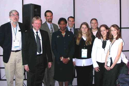
In 2002 and 2003, the Science Team worked with the Edmund Burke School in Washington, DC, USA, and Realschule Cuxhaven, Cuxhaven, Germany, to compare GLOBE AOT measurements with aerosol retrievals from MODIS. The Burke School is about 20 km from the home site for AERONET, at NASA Goddard Space Flight Center. Realschule Cuxhaven is of particular interest because it is a coastal site, on the North Sea. This work was presented at the 54th International Astronautical Congress, in Bremen, Germany, and in a paper published by the International Astronautical Federation [Brooks et al., 2003]. Figure 1 shows the GLOBE team following the presentation in Bremen, along with Dr. Adena Williams Loston, NASA Associate Administrator for Education.
 |
| Figure 1. The GLOBE team at the 54th IAC, with NASA's Dr. Loston. |
|---|
Figure 2 presents two samples of the data generated during this project. They show comparisons of green-channel GLOBE values with the corresponding MODIS aerosol retrievals. An obvious feature of these data is the apparent positive bias for MODIS AOT values evident in the Cuxhaven data, but not in the Burke data. This result is consistent with other studies of MODIS data, all leading to the conclusion that the MODIS aerosol retrieval algorithms consistently overestimate AOT over coastal sites.
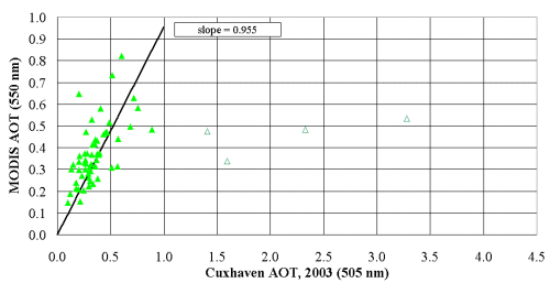 |
| Figure 2a. MODIS/GLOBE comparisons from Realschule Cuxhaven, Cuxhaven, Germany. |
|---|
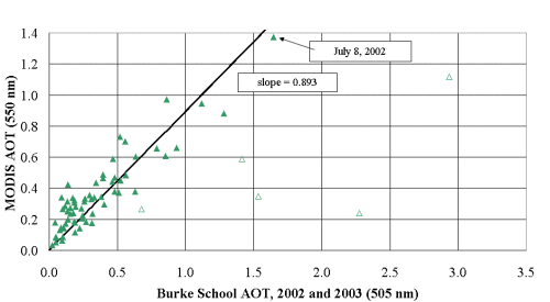 |
| Figure 2b. MODIS/GLOBE comparisons from the Burke School, Washington, DC, USA. |
|
|
||||||||||||||||||||||||||||||||||||
|
|
||||||||||||||||||||||||||||||||||||
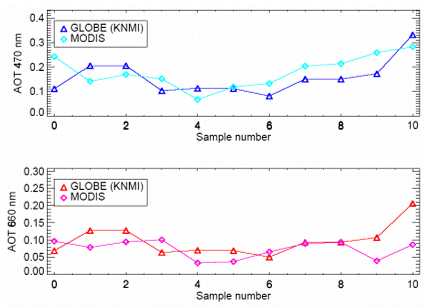 |
| Figure 3a. GLOBE/MODIS over KNMI site at De Bilt (inland site). |
|---|
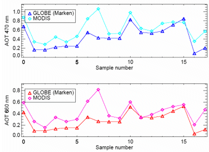 |
| Figure 3b. GLOBE/MODIS over Marken (island site). |
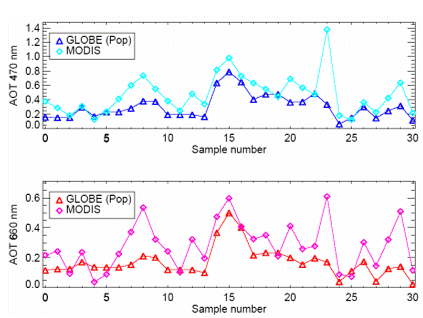 |
| Figure 3c. GLOBE/MODIS over The Hague (coastal site). |
The MODIS aerosol retrieval algorithms require a priori information about the surface, including clouds, from which sunlight is reflected. The algorithms should also discriminate against ground surfaces that are too bright for the algorithms to work properly. Hence, there are never any MODIS aerosol retrievals over bright deserts (thereby providing excellent opportunities for GLOBE student measurements in such places).
In any location that has snow, the problem with MODIS AOT retrievals is obvious: snow is bright, so there should be no AOT retrievals when there is snow on the ground. In some locations, this precludes MODIS AOT retrievals for several months during the winter. Of course, this provides another excellent opportunity for GLOBE student measurements during the winter.
However, it is already known that the MODIS algorithms do not always work properly over snow covered land surfaces. Especially over heterogeneous terrain, even many centimeters of snow do not produce a surface that looks completely white from space. Buildings, trees and other vegetation, open water, and shadows combine to produce a surface that can confuse the algorithms. When this happens, the surface contribution to the observed patterns of reflected sunlight is misinterpreted and there will be major problems with MODIS aerosol retrievals. Even if MODIS algorithms properly interpret some snow-covered surfaces, problems will remain when there is light snow cover, or during the time required for heavy snow cover to disappear completely. At some point in the melting process, the algorithms will resume AOT calculations. Whether they make good decisions can be determined only by ground-based AOT measurements that include human observations of snow cover conditions.
Last fall, the Science Team began a project to examine the performance of MODIS aerosol retrieval algorithms over snow covered land surfaces. Figure 4 shows data from the Philadelphia area collected during the winter of 2003-2004. This is a region (40ºN, near the east coast of the US) where snow cover typically comes and goes during a winter season. The breakdown in MODIS aerosol retrievals is clearly evident in Figure 4, particularly around mid-January and early February. The vertical scale makes it impossible to examine closely the AOT values without snow cover, but both GLOBE and MODIS values are in reasonable agreement for typical winter skies, in a range of around 0.1 for red and green AOT values. The values returned by MODIS during times with snow cover, as high as 2-3 for the red and green channels during mid-January, are clearly wrong.
When the metadata reporting requirements that are already part of the Aerosols Protocol are supplemented by snow cover observations, perhaps including photographs, GLOBE sun photometer measurements provide a unique data source for improving and monitoring MODIS aerosol retrievals over snow. Data from two additional GLOBE schools during the 2003-2004 winter – one about 100 km west of Philadelphia in Waynesboro, Pennsylvania, and another in Croatia – are currently being analyzed. This is an attractive GLOBE project because it can be done during the winter, when schools are in session, and it can be completed during a single school year.
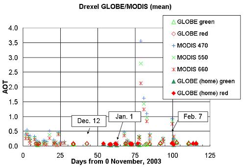 |
| Figure 4. MODIS aerosol retrievals and GLOBE measurements during snow events. |
|---|
Development of the water vapor instrument has been funded by NASA Langley Research Center in support of the now-cancelled Geosynchronous Imaging Fourier Spectrophotometer (GIFTS) project. Fortunately, all development work was completed before the project was terminated. This includes a publication in the NASA Educator’s Guide series [Brooks, et al., 2003] that includes an expanded version of the GLOBE Water Vapor Protocol.
The water vapor instrument is physically identical in appearance to the GLOBE sun photometer. It uses two detectors that measure sunlight transmission through the atmosphere in the near-IR. One detector responds to light in a water vapor absorption band and the other responds to light just outside this band. The ratio of the two detector outputs is related to total precipitable water vapor (PW) in the atmosphere. Current versions use either one LED detector and two filtered photodiodes or two filtered photodiodes. The original plan to use two LED detectors was abandoned because of problems with spectral response and temperature sensitivity for one of the LEDs.
The major challenge for water vapor instruments is their calibration. As there is no reference against which to do direct calibrations, it is necessary to rely on comparisons with other sources of total column water vapor measurements. Two possibilities include water vapor retrievals based on AERONET sun photometer measurements, with extensive atmospheric modeling, and measurements based on analysis of signals from Global Positioning System (GPS) satellites. AERONET sites are distributed (if somewhat sparsely) around the globe. Dozens of NOAA-sponsored GPS sites are found in the United States and Canada. Other countries may have comparable GPS-based programs for monitoring water vapor. Any GLOBE school near one of these sites is eligible to participate in the water vapor instrument calibration project.
Figure 5 shows the calibration process for measurements made near Philadelphia. This location is not ideal for calibrations because it is not close to either an AERONET or GPS site. However, there is a GPS site about 100 km the west and another about 30 km to the south. GPS data are reported around the clock at 15-minute intervals. PW values are always referenced to the atmosphere directly overhead (a relative air mass of 1). In Figure 5, PW values from both GPS sites are shown. Measurements with the GLOBE water vapor instrument are made over a range of air masses, as the sun rises and sets. To compare the detector ratios, the GPS values are adjusted to air masses at the time of the GLOBE measurements. The relationship between the detector ratios and the average of the adjusted PW values from the two GPS sites are then used to calibrate the instrument.
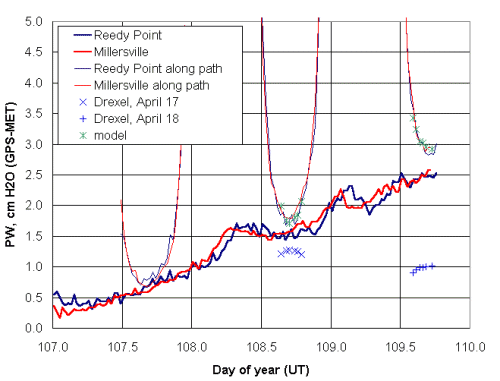 |
| Figure 5. Water vapor instrument calibration procedure. |
|---|
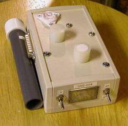
The UV-A instrument has been developed with support from NASA Goddard Space Flight Center, in support of EOS/Aura. It functions as both a full-sky and direct sun instrument (for aerosol optical thickness measurements in the UV), making use of a removable collimator tube. . For use in a full-sky mode, and to protect the LED/filter assembly, the detector is covered with a round Teflon diffuser. Calibration of reference versions of this instrument have been carried out in collaboration with the National Renewable Energy Laboratory in Golden, Colorado. Figures 6 and 7 show a UV-A instrument with its collimator and five reference instruments on the NREL rooftop calibration facility.
 |
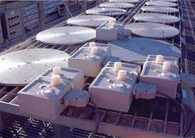 |
| Figure 6. GLOBE UV-A radiometer with collimating tube. | Figure 7. UV-A radiometers being calibrated at NREL. |
|---|
The blue LED detector has a sharp spectral response peak at about 372 nm, in the middle of the UV-A radiation band, as shown in Figure 8. A detector response “shoulder” that extends into the visible part of the spectrum is removed by the addition of a lowpass filter over the LED
The most immediate application of this instrument is to help EOS/Aura scientists understand the temporal and spatial variability of UV-A radiation under a satellite instrument “footprint” several km on a side. It is relatively easy to model the levels of UV radiation reaching the ground under clear sky conditions. However, it is very difficult to model the effects of partly cloudy skies. The Ozone Monitoring Instrument (OMI) on EOS/Aura, in particular, needs a high level of support to provide real ground UV data under the satellite. It is impractical to deploy a large network of expensive UV-A radiometers over a relatively small area, but the GLOBE UV-A instrument offers an extremely attractive solution. Because temporal and spatial variability are primary concerns for UV modeling, the absolute accuracy tradeoffs that are inherent in an inexpensive instrument are offset by the ability to deploy many identical instruments.
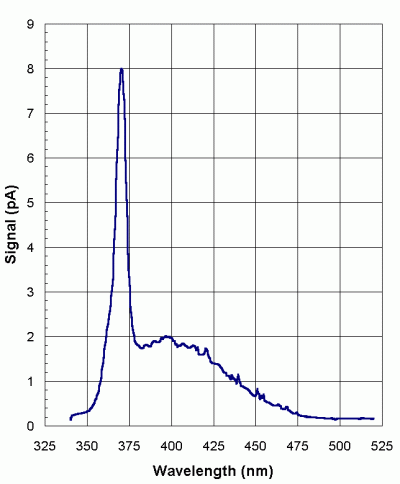 |
| Figure 8. Unfiltered spectral response of UV-A detector. |
|---|
Figure 9 shows a little more than one hour of voltage outputs from a GLOBE UV-A radiometer, logged at 30-second intervals. When used as a ground validation measurement, these data would be collected for about an hour centered around the time of an EOS/Aura overflight. The bottom trace show the detector output in units of volts, which can be converted to irradiance units. The upper trace shows output from the temperature sensor – multiply the voltage by 100 to get temperature in degrees Celsius. As expected, the general output level increases slightly during the measurement time, which is in late morning relative to local solar noon. It is very significant that there is no noticeable temperature dependence for the UV detector output as the temperature sensor warms by about 15ºC in about 30 minutes. This very noisy, partly cloudy sky is typical of the conditions which will cause the most problems for OMI algorithms and which therefore provide great opportunities for GLOBE measurements.
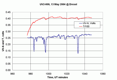 |
| Figure 9. Output from GLOBE UV-A instrument, including temperature channel. |
|---|
At the time this document is being written, the Science Team is looking forward to preparing a UV-A ground validation proposal for EOS/Aura. This will be written as a science project in which GLOBE schools may be able to participate rather than as an education project that may have some additional science benefits. The Science Team believes that, in the context of NASA-funded “Education and Public Outreach” programs for space-based projects, it is essential for the long-term health of GLOBE to more actively pursue science-based funding.
During recent years, there has been much discussion about the lack of publications in the peer-reviewed literature based wholly or in part on GLOBE data. This is partly due to the fact that many of the original GLOBE protocols involved data that were widely available from other sources – temperature and precipitation, for example – in many parts of the world, and offered no unique data products.
In the case of the Aerosols, Water Vapor, and UV-A protocols, we have taken a different approach. In each case, the Science Team has developed new instruments specifically for GLOBE that offer new data collection possibilities to scientists. Each of these instruments is inexpensive enough to allow the establishment of spatially dense networks (although this has not yet been done even with the sun photometer), plus human observations of conditions under which the data were collected. Each of the instruments also includes provisions for data logging in addition to manually recorded observations, which makes them more attractive to the science community.
Because the instruments are new, and acceptance by the science community is absolutely essential to the success of the protocols, the Science Team has taken a deliberate approach to instrument and protocol development:
1. Provide extensive field testing for each new instrument;
2. Describe the instruments in the peer-reviewed literature;
3. Publish our own data in the peer-reviewed literature, to introduce instruments and data to the science community;
4. Define research projects in which students can participate with a high probability of success.
Especially with the Aerosols Protocol, the value of this approach has been proven by demonstrated acceptance of GLOBE sun photometer data by the science community.
Brooks, D. R., F. Niepold, G. D'Emilio, J. Glist, G. Hatterscheid, S. Martin, K. Dede, I. Neumann. Scientist-Teacher-Student Partnerships for Aerosol Optical Thickness Measurements in Support of Ground Validation Programs for Remote Sensing Spacecraft. IAC-03-P.4.07, International Astronautical Federation, 54th International Astronautical Congress, Bremen, Germany, Sept. 28 - Oct. 3, 2003.
Brooks, David R., Forrest M. Mims III, Arlene S. Levine, Dwayne Hinton, The GLOBE/GIFTS Water Vapor Monitoring Project:An Educator's Guide with Activities in Earth Sciences. NASA Publication EG-2003-12-06-LARC, 2003.
Brooks, D. R., and Mims, F. M. III. Development of an inexpensive handheld LED-based Sun photometer for the GLOBE program. J. Geophys. Res., 106, D5, 4733-4740, 2001.
De Vroom, Joris, Folkert Boersma, and Pieternel Levelt. Can Dutch GLOBE schools validate MODIS Aerosol Optical Thickness measurements? KNMI, Presentation at the EOS/Aura Science Team Meeting, October 2003. De Vroom, Joris. The Contribution of Dutch GLOBE Schools to Validation of Aerosol Measurements from Space. Master's Thesis, Vrije Universiteit Amsterdam, October 2003. Mims, Forrest M. III. Satellite Monitoring Error, Nature, 361, 505, 1993.
Tregoning, Paul; Renout Boers, Denis O’Brien, and Martin Hendy. Accuracy of absolute precipitable water vapor estimates from GPS observations. J. Geophys. Res., 103, 28, 701-28,7109, 1998.