Background and data collection protocols for the water vapor instrument are described in detail in the reference at the end of this document. You should read this document, if you haven't already done so, before planning a calibration activity at your observing site.
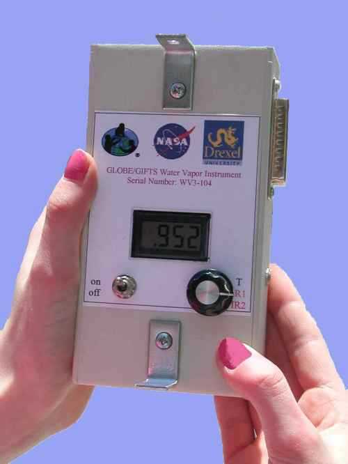
The water vapor instrument is identical in physical appearance to the two-channel visible light sun photometer developed for the GLOBE Program. Data are collected in the same way, by pointing the instrument at the sun and recording the voltage output of the two detector channels. Instead of having two visible-light detectors, the water vapor instrument has two detectors in the near-infrared part of the spectrum. One detector responds to sunlight that is absorbed by water vapor in the atmosphere. The other responds to sunlight just outside this absorption band. When the amount of water vapor changes, the ratio of the output voltages from these two detector channels changes. The calibration process involves associating the detector output ratio with the actual amount of precipitable water in the atmosphere.
Unfortunately, it is not easy to measure the actual total amount of precipitable water vapor (PW) in the atmosphere. If it were possible to do this directly from the ground, there would be no need for this instrument! Instruments mounted on rockets or balloons can be used to determine the vertical distribution of water vapor. In principle, sun photometers can be used along with so-called radiative transfer models of the atmosphere to calculate PW, but this is a more complex set of measurements and calculations than can be undertaken with the two-channel GLOBE sun photometer. There is an approximate relationship between water vapor and dewpoint temperature, which is calculated on the ground from air temperature and relative humidity. However, this relationship is not accurate enough, especially in conditions where weather conditions are changing quickly, to substitute for an actual measurement of PW. (See the discussion of Reitan’s formula in the document referenced below for more information.)
More recently, signals from Global Positioning System (GPS) satellites have been used to calculate water vapor. For an explanation of how this is done, visit this NOAA site: www.etl.noaa.gov/technology/archive/gps/.
In order to calibrate the water vapor instrument, we must rely on comparisons with other sources of PW. Two such sources are the AERONET network of sun photometers and GPS-MET sites. AERONET sites are distributed around the globe, but the network is relatively sparse. There are many GPS-MET sites in the US (including one site in Puerto Rico) and a few in Canada. See aeronet.gsfc.nasa.gov and gpsmet.fsl.noaa.gov for a list of these sites. Data from these sites are readily available online. If your observing site is near one of these other sources, then its PW values can be compared with your measurements to generate a calibration for your instrument.
What does it mean to be "near" an AERONET or GPS-MET site? There is no straightforward answer to this question. In some places where there is a lot of terrain variability, then you need to be nearer to a reference site than if the meteorology in your area is more uniform over larger areas. Typically, anything less than 10 km or so should be "close enough." Note that if you are near an AERONET site, then your instrument looks through the same part of the sky (directly at the sun) as the AERONET instrument. When a GPS site is used, this is no longer a valid assumption, because the GPS measurements encompass a much larger region of the atmosphere. The success of such calibrations can be determined only by actually going through a calibration procedure and analyzing the results.
In order to have a meaningful calibration, outputs from your water vapor instrument need to be recorded over a large range of PW values. When PW is reported, the accepted standard is to reference the value to a column of atmosphere directly above the site. If you are familiar with the terminology used for the visible light sun photometer and its measurements of aerosol optical thickness, this corresponds to a relative air mass of 1. One way to cover a large range of PW values is to look directly at the sun through a range of relative air masses. This means that you need to make measurements over a large range of solar elevation (or zenith) angles. Note that the minimum PW value you can observe is the reported PW value for a particular reference site. For example, if the site reports a value of 3.0 cm (of water), then 3.0 is the minimum PW value you will see looking straight up through the atmosphere. (For any site with a latitude above or below about 23.5° N or S, the sun is never overhead and you will never be able to view the sun through a relative air mass of exactly 1.) In some places and times, PW values can be much smaller than 3.0 -- as small as a few mm of water.
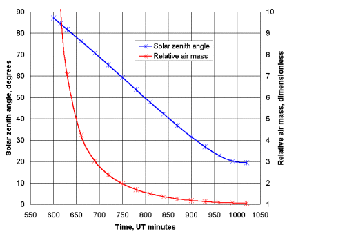
Ideally, you would like to be able to predict the times for evenly covering a wide range of relative air mass values. The graph below shows solar zenith angle and relative air mass at 40°N, 75°W, on the morning of 22 May 2004. The "*" symbols are at 30-minutes intervals, plus one extra point at 6:15 local time (Eastern Daylight Time.) In this graph, relative air mass is calculated as 1/cosine(solar zenith angle). This is an approximation that does not account for atmospheric refraction at high zenith angles, but it is sufficiently accurate for this purpose. At this time of year and this location, the sun rises at about 5:39 EDT (579 minutes UT) and sets about 8:16 EDT (16 minutes UT on the next calendar day). Local solar noon occurs at about 12:57 EDT (1017 minutes UT). You can get these values for your location from any of several online sites, including an excellent site maintained by NOAA at www.srrb.noaa.gov/highlights/sunrise/gen.html
|
For a morning calibration, you need to start just after sunrise and continue until an hour or so after solar noon. Note that the widest range of relative air masses occurs during the first couple of hours following sunrise. As you approach local solar noon, the relative air mass changes much more slowly. So, it is important to make more frequent measurements during the early morning. For an afternoon calibration, the conditions are reversed, and it is important to make more frequent measurements approaching sunset.
It is much easier to compare your measurements with other measurements if they are taken at the same time. As a practical matter, it is not possible to predict the exact times at which AERONET measurements are made (every 15 minutes or so). However, the GPS-MET water vapor data are reported every 30 minutes at 15 and 45 minutes after the hour. So, if you are using GPS-MET data for calibration, you should record data within a minute or two of 15 and 45 minutes after the hour.
Regardless of whether you are using an AERONET or GPS-MET calibration source, it is still helpful to take measurements as frequently as possible, especially when the sun is low in the sky. This will provide valuable information about the consistency of your measurements, even if the "extra" data will not be used as part of the calibration. If you are calibrating against AERONET data, it may be necessary to interpolate between sets of measurements in order to obtain an averaged value that is as close as possible to an AERONET measurement time. In this case, it is better to have as many measurements as possible.
The ideal conditions for calibrating a GLOBE water vapor instrument occur on dry days with clear skies, over low-elevation sites (so the PW values aren't too low). Then you can collect data during an entire day, starting in the early morning and ending in late afternoon. The nearer the sun is to the horizon, the more atmosphere is between you and the sun (because the relative air mass is larger), and the more PW your instrument will see. The drier the atmosphere, the more of the lower PW range you will be able to calibrate. In some places, at some times of the year, cirrus clouds are very common. As long as these clouds are thin and relatively uniform, it may be OK to collect water vapor data with a calibrated instrument. However these conditions should be avoided during a calibration cycle. Conditions with lower clouds or well-defined cirrocumulus should be avoided in any case.
It is impossible to say how long will it take to calibrate a GLOBE water vapor instrument. Under ideal conditions, it might be possible to collect a reasonable amount of data in only one day of measurements. In other cases, it might take days or even weeks to accumulate enough data. It is also possible that instruments intended for use only in certain climates need to be calibrated only over a range of PW values appropriate for that climate. For example, the range of water vapor content of the atmosphere above high deserts is much lower than it is above tropical rain forests.
The procedure for collecting calibration data should follow the procedure defined in the document referenced below (see the data reporting forms linked from the document referenced below). Each "measurement" should consist of three sets of IR1/IR2 voltages, taken sequentially over a period of no more than 2 or 3 minutes. The detectors in your water vapor instrument are somewhat temperature sensitive, and it is important to keep the air temperature inside the case between 20-25°C. This may require some careful planning, depending on the ambient air temperature. Use an insulated cooler when it is hot and keep the instrument under your coat between measurements, for example, when it is cold. The more constant the case temperature is during the entire calibration cycle, the better your calibration will be.
Regardless of when you collect data, it is very important to record times accurately in order for the required solar position calculations to be done accurately. You can use a GPS receiver, or a watch or clock set manually from www.time.gov or automatically by a government-maintained radio signal (WWBV in the United States). Time can be read to the nearest 15 seconds even with an analog watch that has minute marks on its dial.
Once you have collected your calibration data, you can send them for processing to:
Dr. David R. Brooks
Institute for Earth Science Research and Education
2686 Overhill Drive
Norristown, PA 19403 USA
e-mail: brooksdr@drexel.edu